Struve Arc: 40 years of painstaking measurements for accurate maps
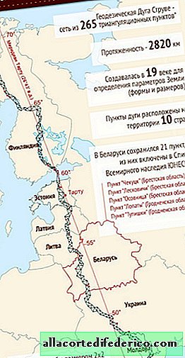
In several European countries, from Moldova in the south to Norway in the north, there are more than 30 unique triangulation points that are part of the Struve Arc. This is the legacy of a grandiose geodetic project, which was carried out at the expense of the Russian Empire and was aimed at clarifying the true parameters of the Earth. In order to find out, scientists for 30 years took painstaking measurements and created a unique triangulation network with a length of more than 2,800 kilometers.
Work on the study of the size of our planet was conducted under the guidance of V. Ya. Struve in the first half of the 19th century. Of course, by the time engineers and surveyors set about creating a triangulation network that crosses all of Europe from north to south, scientists already had an idea of the size of our planet. But the data on the polar and equatorial radii, as well as other parameters important for the compilation of geographical maps, were not entirely accurate. These errors continually surfaced in the preparation of the next atlas or map and did not give scientists peace. The military and travelers, the main users of geographic maps of that time period, suffered primarily from such errors.

In order to clarify geodetic calculations once and for all, a decision was made to carry out large-scale measurements, headed by Vasily Yakovlevich Struve, a Russian scientist-astronomer of German origin. Such a large-scale work required a significant amount of time - the Struve geodetic arc was created over 40 years. But the result was worth the effort and money. As the latest satellite studies have shown, scientists of that time determined the parameters of the triangulation network with incredible accuracy, and the maximum deviations do not exceed 2 centimeters.

Work on the territory of the Russian Empire was carried out with the support and direct participation of the St. Petersburg Academy of Sciences. But for more reliable calculations, one territory of the Russian Empire from the Black Sea to the northern borders of Finland was not enough, therefore, Norway and Sweden, united at that time in one state, were involved in the project.

Thanks to the established triangulation points, and there were more than 260 of them, V. Ya. Struve was able to most accurately determine the parameters of the Earth, which formed the basis of subsequent geographical maps and were used until the middle of the 20th century. At the moment, 34 strongpoints from the Struve Arc have been preserved, most of which are located in Belarus, Ukraine, Finland and Norway. They are recognized by humanity and included in the list of UNESCO sites.

Watch the video: Struve Geodetic Arc - UNESCO World Heritage Site (May 2024).


-
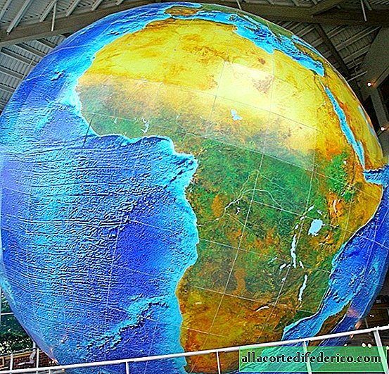
Where is the world's largest globe with a diameter of 12.5 meters
Many held a globe in their hands, rotating which, you can quickly find any point on the Earth’s layout. But there are such globes that it is impossible to pick up and quickly find the place of interest on them, and in order to examine the surface from the North to the South Pole, you will have to rise to the height of a 3-storey building. ... -
-

-